August 21, 2010. Originally, I was going to bike the Cattail State Trail which begins in Amery, and runs east to Almena. After scouting ahead in Amery, I found that it isn't a proper bike touring trail, but a year-round multi-use trail (walking, mountain biking, horseback, snowmobiling, ATVs) with a rough gravel surface. As previously stated, perhaps sometime I will do the rougher trails with my Trek, actually a mountain bike (I've had the tires switched to hybrid for smoother road action) but that's a few miles down the trail. I prefer the screened limestone/paved trails for now. Touring trails. While I was gathering information in Amery, I discovered the Stower 7 Lakes Trail was officially opening later that week. What luck!
The City of Amery's website isn't current, since it doesn't list the trail as having been upgraded. Many websites might not even list its existence since it just opened August 21. You got the news here first. The trail is now surfaced with screened limestone, and was in very good shape the day I rode it.
There is a parking lot just to the south (or left) of me. There are plans to build a community building by the trail head, but for now, look for a small park and a parking area near the intersection of Harriman and Center Avenue, just west off Hwy. 46 which runs right through Amery. (Cattail Trail is pretty much opposite this trail head, across Hwy. 46, behind the Fire Station which faces the highway.) Easy to find.
The opening was well attended! State Senator Sheila Harsdorf was there, Matthew Frank, DNR Secretary, and other speechifiers. The "Stower" of Stower 7 Lakes State Trail refers to Harvey and Marilyn Stower. Harvey Stower served as a state representative of the 28th assembly district, and as mayor of Amery for many years. He died in September, 2009. Family members cut the "opening of the trail ribbon".
I expected a big clump of bikers fighting to get to the front, but no such thing. Most of the people in the crowd were just there for the speeches, I guess. Many of those people had worked to build and improve the trail as volunteers, so........THANKS! I hope they enjoyed the celebration and felt rewarded. I do so appreciate a good bike trail. Probably there were a couple dozen or so cyclists.
After that, I was off down the trail. The day was somewhat overcast, which is a good thing for biking. The trail was open with wetlands and fields on either side, or woods, or one of the seven lakes would appear. Actually, I count six lakes on my road map, but I'm sure they didn't make it up.
There are small road crossings, and one highway crossing. Everything is well marked.
Since it was opening day, "rest tents" were stationed along the way with drinks, and a place to cool off. The first stop is Deronda, 3.6 miles after Amery.
The trail is fourteen miles long. It is easy biking, no hills, not even much of an incline that I can remember. A very new way station is located just after Deronda.
You can park your bike here. You can sit under an awning. You can throw things away, and hopefully recycle them. You can use this pretty fancy outhouse, but you can't get a drink because there is no plumbing. About this time, you might be thirsty, but no such luck. That is why you carry a water bottle. Frankly, from this photo, the outhouse looks more like a smokehouse with that chimney. I didn't go in there.
Still thirsty? It's been 3.7 miles since Deronda. See the sign for Wanderoos? Go to the right a few blocks. Bike around Wanderoos. Wanderoos. Wanderoos. Wanderoos. Hee hee. It's fun to say. Try it. I don't think the town was named after Macaca silenus: a monkey of South Central Asia having a glossy black coat and ruff of gray hair about the face, pronounced wan-deh-roo. I just don't think so. Further research must be done. But back to that thirsty business.
Bike to this most excellent place. It's historic, you can attend school, and quench your thirst all at the same time. When you go through the front door, go downstairs. Don't go upstairs. I did that. People live there.
This is the second bar on a bike trail, where a bike lottery is featured. Not only can you bike a trail, but you can win a bike! Worth it!
I just wanted a shortie, so it was a Coors Light. I'm not a light beer fan, but it's probably not a bad idea when biking. You can see that this is a friendly place.
Back on the bike and on the trail..........a major change of scene from a glowing, friendly tavern to a spooky wetland. Actually, it was really pretty, with lots of birds.
Pedal for 4.6 miles and arrive at Nye. If you actually want to visit Nye, you must turn left at the small road before this sign on the trail. The trail does not go into Nye. I did not turn off the trail to experience Nye. Sorry, nothing to report.
2.6 miles after Nye, The End. Well. And it does just............end.
You can see that it could keep going. If it did, this trail would connect with the 98 mile long Gandy Dancer State Trail that begins in St. Croix Falls, WI, goes up to Danbury, WI, wanders about in Minnesota for a bit before finding its bearings and returns to Wisconsin to end up at Superior. The old rail bed is there for the trail to be built on, but ownership of a section by a quarry interrupts its completion. Perhaps someday this will be part of a very long trail system. But there is that funding problem, and somethings tells me that the recent political switch isn't going to favor the development of bike trails.
To the right (east) of the trail end, is Lotus Lake County Park. This would be a good place to park a car if you want to start from this end, or be picked up. Just bike for .03 miles. Since there was a reward for me to do so, I did.
The last "rest tent". The park is small and charming, and there were.......................
friendly people with.............................
COOKIES!! I only had one. Guess which one? No, you are not going to win anything. "Pedal Power On The Stower". Because this was not the end for me. I had to return to my car in Amery, which was 14 miles back. So eat the cookie, girl, turn around and pedal some more. And no stopping in Wanderoos.
Trail information contact: Wisconsin DNR, City of Amery, Wisconsin, Facebook Friends of the Stower Seven Lakes State Trail, Polk County, Wisconsin
Trial head location: Amery, Wisconsin (Harriman and Center Avenue, off Hwy. 46 across from the Fire Station)
Length: 14 miles
Usage: (Summer) walking, biking non-motorized (Winter) walking, snowshoeing, cross-country skiing (untracked).
Highway crossings: Small roads, one highway, well-marked.
Surface: Limestone screenings
Scenic: Pleasant
Signage: Directional signs and mile markers, yes. Historic signs and better end of trail sign would be nice.
Regional trail system: Not yet.
Rest stops: village of Deronda, village of Wanderoos, way station after Deronda. (toilet only, no water there)
Those are the facts, Jack. It was a pleasant trail. My congratulations for the new opening and to the volunteers who undoubtedly worked very hard to make it happen. Wanderoos, Wanderoos, Wanderoos.................
Mantra: Keep on pedaling and no bears.
Wednesday, November 10, 2010
Sunday, October 17, 2010
Stormy Weather: The Elroy-Sparta Trail
August 7, 2010. My sister, Jen, and I drove both our cars down to Wilton, WI to stay at the excellent Amil's Inn (Bed & Breakfast). Wilton is positioned midway on the Elroy-Sparta State Trail. My plan was to bike the top half (Sparta to Wilton) on Saturday, and the last half (Wilton to Elroy) on Sunday, then the two sisters would part and go back to respective homes. Two cars were needed because not only would we be driving back in different directions, but we thought we would leave one car at the head of the trail (bringing the bikes) and one at the end to pick up the bikes, go back and get the other car, and return to Amil's when the day was done. It turned out that we only needed the two cars to return home with, because Amil's offered the service of drop off (for a fee) on the trail, which was great! At the end of our first half of the trail, we just biked from Wilton to Amil's, and I estimate that distance to be about 2-3 miles. David and Anita Reeck are the Amil's Inn hosts. I HIGHLY recommend staying there.
Lovely plantings in front of Amil's |
After we settled in, our bikes were mounted on Anita's bike rack. The route up to Sparta along Highway 71 is rolling and scenic. It also made me think about biking all those hills, but no worries! Rails to trails are pretty much flat, with some grade changes. Consider that since these trails were for trains in the first place, and that to promote efficient travel, trains needed level ground. Hence: TUNNELS. And these tunnels are awesome.
Sparta, Wisconsin, is all about the bike. We didn't have time to explore the town, but judging from our drive through to the trailhead, it was a tidy and attractive place. Further research must be done. (Another personal mantra.) Above see the two sisters, Jen on the left (taller) and me on the right.
I don't time my rides. I do note the distance for informational purposes. I do stop often and explore towns along the way, and I also take lots of photos. This makes progress slower, so noting how long it takes me do ride a trail is like measuring how long it takes me to record information: variable. I will say this: Jen is a faster ride than me. My excuse (and I have plenty): my bike is heavier. I take photos. I stop and look. And other whiny sister excuses. Maybe some day I will get a fast bike, and whiz along, but until then I am built for information, not for speed. Generally, I bike alone. Like the song. (Change "I Drink Alone" to "I Bike Alone".) I judge that I am an annoying trail bike companion because of all the stopping, but Jen was great to bike with, and we seemed to achieve a balance of progress and information gathering.
I love it when the trailhead office is the old railway station. The Red Cedar State Trail in Menomonie has a railway depot also. So appropriate. Find the Sparta trailhead at the Sparta Chamber Depot, 111 Milwaukee Street.
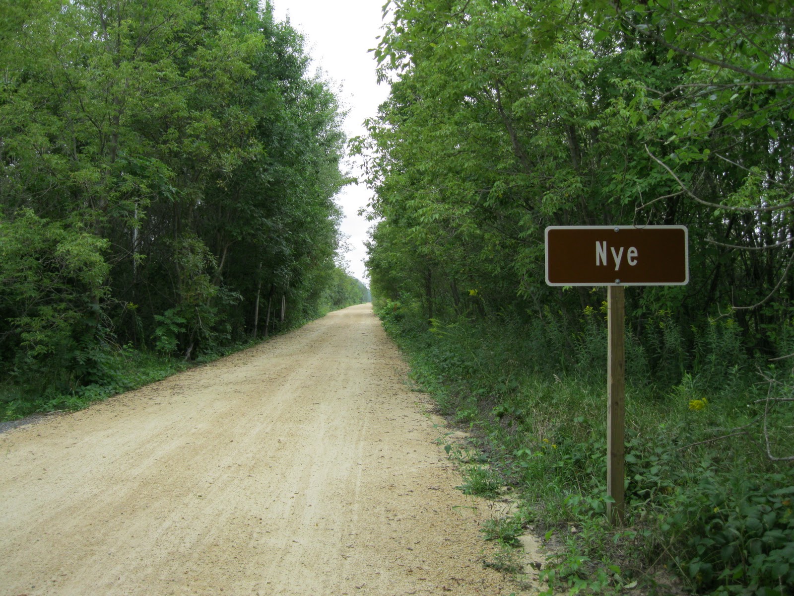
And off we went! You can see that the surface is crushed limestone, not asphalt. Surprisingly, the trail is not as wide as the others I have previously biked. Also, there are no mile markers, which I found to be odd, and disappointing. The Elroy-Sparta State Trail is the oldest (and first) rail to trail conversion not only in Wisconsin, but in the nation. I can understand that since it is the first, the trail is more narrow than others created later. But no mile markers? Those could be added at any time, and not at great expense. I don't understand. However, since the trail begins and ends in towns, with others along the way, confusion about distances is not such an issue. But still.
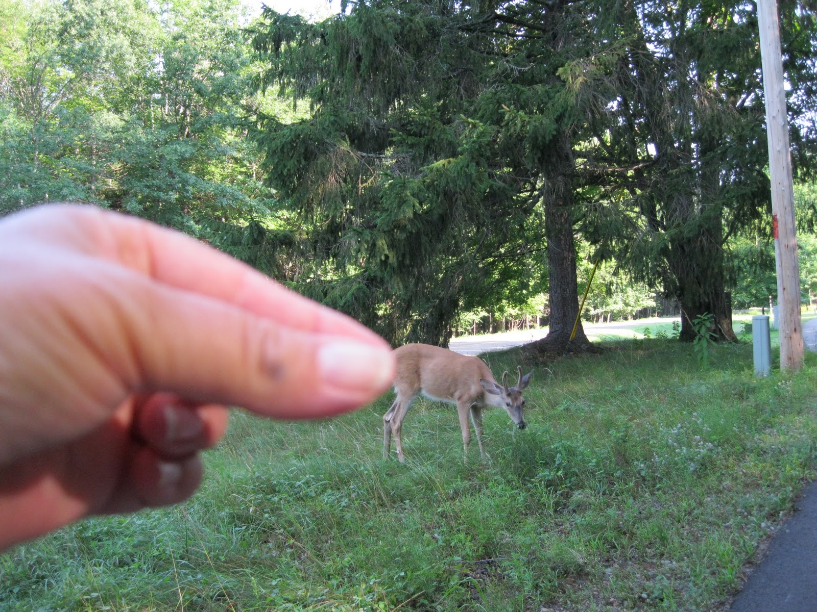
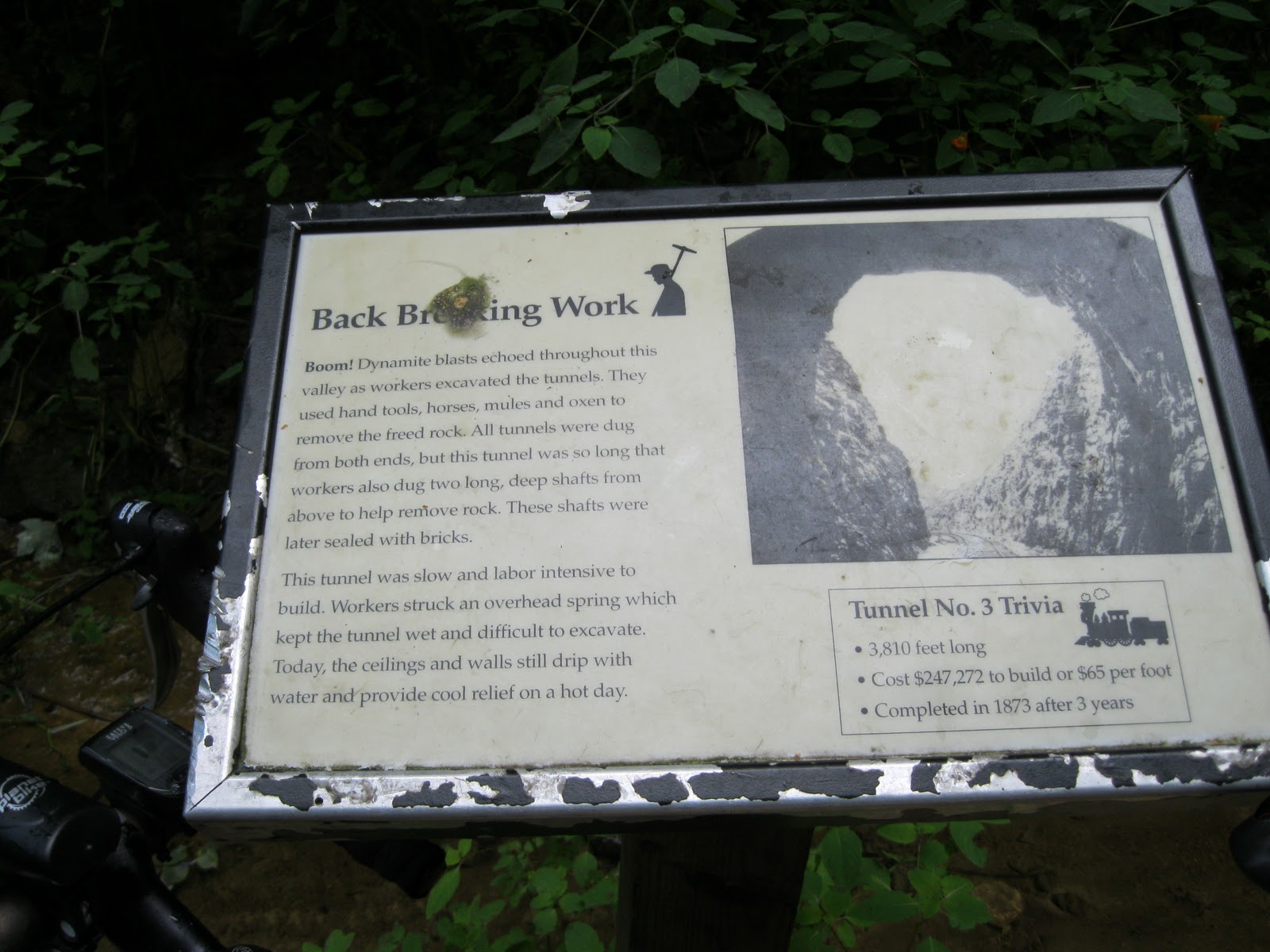
You can imagine that such geography would make laying a rail bed a challenge. Historical markers along the trail introduce you to the experience of earlier times. Tunnel #3 (and because we started at Sparta, we were going "backwards".......once again......#3 was the first tunnel we approached) was completed in 1873, and when we walked through it, seemed an engineering marvel. It also was very refreshing on a hot, muggy day. Note that we walked through it. Bikers must walk their bikes through, and please adhere to the "stay on your right side" rule, since it is pitch black inside there. Have a bike light or a flash light, or collisions (OW) will occur. The tunnel is so long that you cannot see light at the end. It also is foggy, and water drips from the ceiling, and a small stream runs along one side. Very cold water. The approach to the tunnel reminded me of entering Mammoth Cave in Kentucky. Cool air and mist roll out of the entrance. It's like entering a cold hell, dark, cool, mysterious. I just loved it.
Pinpricks of light bobbing along become cyclists leaving the man made cave. They made it out alive! Now it's your turn. Bwaaahhhhahaha. Must be good at Halloween.
And we were out. Here to tell about it.
Once out of the tunnel, we mounted the bikes again. There had been an incline grade up to Tunnel #3, but now it was a slight coast down. Yes! And then we came upon this quainty-old timey scene:
I think all present-day schools should have a hand pump. Kids like them. This water was really good and welcome. We sat for a while, enjoyed some power bars, drank water and watched the fun.
The next stop was the village of Norwalk, as you can see, they have a black squirrel problem. Might as well name it the Black Squirrel Capital, and make it an asset. We rode into town to see if it was true.
They weren't kidding. Look at those little devils. Looking at YOU! We explored the main street and made note of a place we might like to return to later (by car) for supper. And then, of course, we had to have a beer before hitting the trail again. (It's Wisconsin!)
Here we are at Lil's Corner Bar. Other cyclists were there also. We passed them, they passed us, we passed them............I think we finished our beers first though. Then back on the bikes, to proceed to Wilton, back to Amil's and the jacuzzi that we both enjoyed in each of our rooms.
Oh, and there was Tunnel #2 before Wilton. It was not as long as Tunnel #3, the light at the end of the tunnel can be seen.
The length of the whole trail from Sparta to Elroy is 32 miles. We did half, so 16 for us on Saturday. Later we returned by car to Norwalk to eat here:
Los Tres Garcias. Family run, homemade, generous portions, really good. Eat there.
Later on, the bed. It was comfortable and welcome. I heard it raining during the night, and was wondering how our second half of the trail would go.
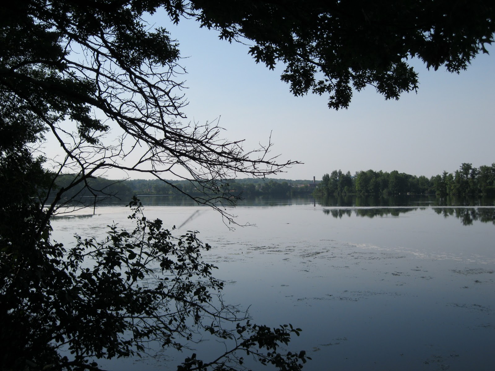
This was the view from my room's window in the morning. I could tell that a revision of the day's plan was in order. We discussed it over breakfast, and decided that biking in the rain would not be all that pleasant. The last half of the trail will be done another time. But first.........breakfast!
First course.
The breakfast is excellent, (french toast later) and the cozy white robe is provided also. Even though we did not get to finish the trail, we had a good time, and look forward to the second half of the trail. Maybe I will bring my husband here next time.........................
Trail information contact: Friends of Elroy-Sparta State Trail Wisconsin DNR Friends of the Four Trails Trails From Rails
Trail head location: Elroy, WI (Elroy Commons, between County Hwy. O, and Hwy 80/82) or Sparta, WI (Sparta Chamber Depot, 111 Milwaukee Street)
Length: 32-34 miles, depending on source of info
Usage: (Summer) Biking, hiking, non-motorized. (Winter) Snowmobiling, cross-country ski (ungroomed).
Surface: crushed limestone
Highway crossings: For the section of Sparta-Wilton, just a few back roads. Nothing major. Observe the stop signs.
Scenic: Are you kidding? Oh yes. Oh the tunnels=fun.
Signage: Historic markers, and main trail map signs, yes. But what happened to the mile markers?
Regional trail system: Well, I don't know what the system is called (maybe Bike 4 Trails?) but it involves 4 trails in the southwestern area: Elroy-Sparta State Trail, the Great River State Trail, the La Crosse River State Trail, the 400 State Trail. See the link above for Friends of the Four Trails.
Rest stops: Sparta Chamber Depot, village of Norwalk, village of Wilton. In the future, I will give info for the second half of the trail.
Those are the facts, Jack. I love this trail, the tunnels are awesome, quirky little towns along the way, beautiful scenery, I can't wait to finish it. Oh honey............let's stay at a bed and breakfast this weekend, bring your bike!
Mantra: Keep on pedaling and no bears.
Saturday, October 16, 2010
Who IS Old Abe Anyway? Biking the Old Abe State Trail
Previous postings have documented the Red Cedar State Trail (Hometown Trail) and the Chippewa River State Trail (Mosquito Land). The September 22nd posting (Best Laid Plans: The Bike Trail List) gave the overview of bike touring trails that I will be traveling. Forward (as we say in Wisconsin---state motto) to the Old Abe State Trail.......or maybe backward, since I biked this back on July 29th.
In 1861, a Chippewa tribe traded an eaglet to Dan McCann of Jim Falls, Wisconsin. What did the tribe get in return? Hopefully not useless trinkets. Dan kept the eagle as a pet, and then gave it to the Eau Claire Company C of the 8th Wisconsin Infantry formed for the Civil War. The eagle was named in honor of President Lincoln. Old Abe traveled with the company during 37 battles, (the number of battles differs according to sources) and then returned to Madison, where it died in a fire. Well, poor eagle, I say. It didn't get to fly free, and then, death by fire also. However, this trail and probably other things were named after it. Its likeness is displayed in the Wisconsin State Capitol.
View the trailhead map. Jim Falls is about 12 miles down the trail, so pee now. Mill Yard Park has facilities. Cornell has various restaurants and bars for visiting purposes. The Brunet Island Park office is not always open.

Rest stops: Brunet Island State Park, city of Cornell, (1.2 miles) village of Jim Falls, (12 miles) city of Chippewa Falls (about 23 miles), No facilities at Anson Station parking area ("end" of trail-18.1 miles).
Those are the facts, Jack. I enjoyed the top half (Jim Falls to Cornell) the best. The mystery of getting into Chippewa Falls was a challenge, but it worked out. I enjoy the Chippewa Falls downtown and recommend it.
Mantra: Keep on pedaling and no bears.
In 1861, a Chippewa tribe traded an eaglet to Dan McCann of Jim Falls, Wisconsin. What did the tribe get in return? Hopefully not useless trinkets. Dan kept the eagle as a pet, and then gave it to the Eau Claire Company C of the 8th Wisconsin Infantry formed for the Civil War. The eagle was named in honor of President Lincoln. Old Abe traveled with the company during 37 battles, (the number of battles differs according to sources) and then returned to Madison, where it died in a fire. Well, poor eagle, I say. It didn't get to fly free, and then, death by fire also. However, this trail and probably other things were named after it. Its likeness is displayed in the Wisconsin State Capitol.
My husband dropped me off in Cornell, Wisconsin at the area that I thought was the trailhead. He would later pick me up in downtown Chippewa Falls, where I thought the end of the trail was. It wasn't. The day started in confusion about where the exact beginning and end were located, and perhaps this is not confusing to other people, but it was to me. But to YOU it won't be confusing! I am making the mistakes for you! That is the benefit of this blog. I pedal around and around the Mill Yard Park parking lot in Cornell, looking for the trail, so you don't have to. Here's the hint: go east across the parking lot, cross Park Road, and the trail runs pretty much parallel to Park Road here. You can leave your car at this parking lot, and access the trail here, or (and I recommend this) drive further (just over a mile) up Park Road to Brunet Island State Park (there's a lot of park park park going on here) and PARK your car by the office. It is pretty here. It's a good place to start. The official head is actually at the Mill Yard Park though. Just so you know. (Or maybe it is the Official End.)
There are lots of tiny deer here. Ha. Seriously, there are lots of deer. Look out when biking. They are rather tame. View the trailhead map. Jim Falls is about 12 miles down the trail, so pee now. Mill Yard Park has facilities. Cornell has various restaurants and bars for visiting purposes. The Brunet Island Park office is not always open.
The top of the trail winds about with the Cornell Flowage alongside. A short stretch of biking along the shoulder of Park Road and then cross to the trail that continues on the east side of the road. Carry on for 18-19 miles!
Yes, it is paved. Easy going. I have read some reviews complaining about the condition of the asphalt, but there aren't any tremendous potholes. Sure, there are some bumpy sections from Jim Falls to Cornell, and be sure to watch for fallen branches. During the summer of 2010, there were lots of storms that brought down tree limbs. I am always surprised to find how quickly these are cleared from the trails. BUDGET CUTS, PEOPLE. Picking up branches for you may not be at the top of the list, so pick up a few yourselves. Unless you want to pay more taxes. See, that's what all the complaining about paying taxes gets you: no one will be picking up your branches, if you don't want to pay for services.
Lovely rural views happen along the way, also woods and the Chippewa River. It is a beautiful ride.
I asked two hikers about the cooler. They told me it contained eggs for sale on the honor system. I didn't check the contents, but I had thought perhaps water bottles were for sale, which would be a good idea!
This is an interesting bridge, I had never seen one quite like it before. Take your turn on this bridge. One at a time. It is found when the trail crosses County K, so check it out. Old timey.
Here is evidence of local amusement. "Things" happen along trails, hopefully not when I am biking though.
The village of Jim Falls offers refreshments, restrooms at the convenience store, restaurants and BARS (Wisconsin). It won't take long to explore the main street, so veer off a block or so to the west and visit.
Historic information will tell you about Old Abe, namesake of the trail.
Large things in Jim Falls. Hydro-electric plants. Eagles. Cheese plants. Very Wisconsin. We like cheese production to be large!
The country becomes farmland and more open. The trail is smoother after Jim Falls, as the woods is left behind.
Wildflowers enjoy the sun. Be prepared for much less shade. Also, a horse trail runs alongside the bike trail which adds to the experience. Unfortunately, no one was out riding when I was. I was hoping to see some equestrians.
Soon I was at the Anson Station parking area, which sources list as the official end (or beginning) of the Old Abe Trail. It would be a good place to stop, but this bridge beckons just a block or so south of Anson Station. If you have decided to end the trail here, be sure to ride over the bridge and then return to your car. It is a great bridge to ride across. Like a mini roller coaster. The trail will someday continue into Chippewa Falls, and on into Eau Claire which would then connect with the previously posted Chippewa River State Trail, and the Red Cedar State Trail, bringing cyclists from Cornell to Menomonie. I am looking forward to that. The confusing part is: there already IS a trail continuing beyond the official end of the Old Abe at Anson Station, this wavy bridge being part of it. I did not realize that Anson Station was the "end" and so I went on, thinking that I could easily get into downtown Chippewa Falls. There should be a sign saying The End of The Old Abe State Trail, Starting A City Trail Into Chippewa Falls. One That Doesn't Go All The Way Into The City, So You Can Be Confused. Dear Readers: I did get there. But only because I was somewhat familiar with Chippewa Falls. If you were from somewhere else, good luck. This is a problem with many state bike trails. The end of the trail is not marked well. There should be a Big TA DA! Congratulations! You made it! Now turn around and go back.
To get to downtown Chippewa Falls, continue on the trail. It will look just like the trail you have been on for 18 miles, which makes you think that you are still on the Old Abe State Trail. As the above photo shows, Chippewa Falls is closer.
After crossing Highway S a couple of times, and biking alongside it, you will leave S behind, following County I and come to a new suburban development, and this is where it could become confusing........as it was to me.
This is the new development. It is alongside a recreational area that has a nice bike path going through it, I know because I mistakenly went there. It is pretty, and you can go on it, but you won't get into downtown Chippewa Falls if you do. So, at the intersection of County I and Seymore Cray Sr. Blvd. cross County I to the right, going west. There are traffic lights, and a pedestrian right of way button. Use it.
County I turns to the right here also, so you are still following it, and you are still on a bike path. This street (County I) is also called First Avenue. Go for a couple of blocks and turn left off First Avenue, going south, onto Scheidler Road. This will be street biking, you have left the trail, but not much traffic at all, and there is a "bike lane" albeit rather narrow. St. Joseph's Hospital (to the right) is a landmark. Follow Scheidler Road going down a fairly steep hill through an area of apartments and industry/warehouses. Curving to the right, merge into Pumphouse Road. Pass Timber Terrace Golf Course. Pumphouse Road will curve a few times, and then a railroad crossing approaches. Look for a bike path here, by a trestle bridge that is in use by trains. Cross (left) Pumphouse Road onto the path which follows the Chippewa River. This path into downtown Chippewa Falls is scenic, but short.
Pick up the trail here from Pumphouse Road. Note the bike route signs. |
The city river path ends at the sidewalk. The Highway124 bridge over the Chippewa River is to your left. To downtown Chippewa Falls, turn right onto the sidewalk. From here, just continue straight ahead to downtown. But for a treat, follow these directions!
Pay attention to the brown Heritage sign. You HAVE heard of Leinenkugel beer, right? Follow that sign. Curve to the right. Follow the bike route signs. Turning onto this little street and that, along scenic Duncan Creek, a short city bike path through a quirky neighborhood and then to the Mecca of............................
LA LA LA (Heavenly choir singing.) The Jacob Leinenkugel Brewing Company. Take the tour. You know you want to. Besides, if you do, you get to go HERE (photo below) and get free samples. It also is an excellent place to leave your car, or call someone to pick you up, which after those samples might be the better idea.
The tasting house is by a local swimmin' hole in Duncan Creek. Another idea is to go to Bridge Street (the main street downtown) and check out good eats at Lucy's Delicatessen and Duncan Creek Wine Bar. Explore other businesses in downtown Chippewa Falls, it is charming.
Wasn't biking into Chippewa Falls a good idea? Eh? Pretty bridges over Duncan Creek, good food, beer samples............almost makes you forget your sore butt.
Trail information contact: Friends of The Old Abe State Trail, Wisconsin DNR
Trail head location: Park Road off Highway 64 (Bridge Street) in Cornell, WI.
Length: 18.1 miles to Anson Station. About 5 miles (?) to downtown Chippewa Falls.
Usage: (Summer) Walking, biking, inline skating nonmotorized. (Winter) Cross-country skiing (ungroomed), snowshoeing, snowmobiling. Parallel trail from Jim Falls to County Hwy. O for horseback riding.
Surface: Asphalt.
Highway crossings: Yes, some main highway crossings as well as back roads. Beware. When closer to Chippewa Falls, major highway crossings using a pedestrian right of way.
Scenic: Yes, especially the portion from Jim Falls to Cornell which hugs the Chippewa River. From Jim Falls to Chippewa Falls, open farm land. From Anson Station to Chippewa Falls: farm land, suburban streets and industrial areas.
Signage: Yes, but could be better, especially marking the actual end of the trail: confusing.
Regional trail system: Chippewa Valley Trail System: Chippewa River Trail, Red Cedar Trail, Old Abe Trail. The Chippewa River Trail will be connected to the Old Abe Trail in the future making it possible to bike from Cornell, WI to Menomonie or Durand.Rest stops: Brunet Island State Park, city of Cornell, (1.2 miles) village of Jim Falls, (12 miles) city of Chippewa Falls (about 23 miles), No facilities at Anson Station parking area ("end" of trail-18.1 miles).
Those are the facts, Jack. I enjoyed the top half (Jim Falls to Cornell) the best. The mystery of getting into Chippewa Falls was a challenge, but it worked out. I enjoy the Chippewa Falls downtown and recommend it.
Mantra: Keep on pedaling and no bears.
Subscribe to:
Posts (Atom)